Adelaide 2036
ADL 2036

Give me the loop

Welcome to the good timeline. You’ve landed in the only Australian city wrapped entirely in parkland, with the bones of a great city already in place. This isn’t just about a tram. It’s about making Adelaide cool again: streets full of life, 50,000 people living in town, and a centre worth staying in after five. A loop along Morphett, Sturt, Halifax and Pulteney could get us there by our 200th birthday.

Adelaide 2036

Sliding Doors: how Adelaide’s tram loop could open up a parallel universe.

The City of Adelaide wants 50,000 people living inside its borders by the time “South Australia” turns 200. The city’s previous peak was 43,000 in 1915, when people walked, rode bicycles and used the tram. By 1972 the city’s population had dwindled to 14,000. This is a short story about how we lost that 1915 city, and the six decisions we could make if we want it back.

Adelaide was planned before it was built. Colonel Light drew the grid in 1837. By 1915, 43,000 people lived inside it and electric trams ran out along the main roads. By 1931 the network reached 133 route kilometres. By 1972 the city was down to 14,000 people, the trams were gone, and a freeway plan had just been shelved. Two hundred years, five generations of one family, and the receipts they kept.

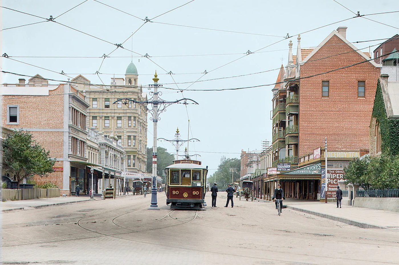
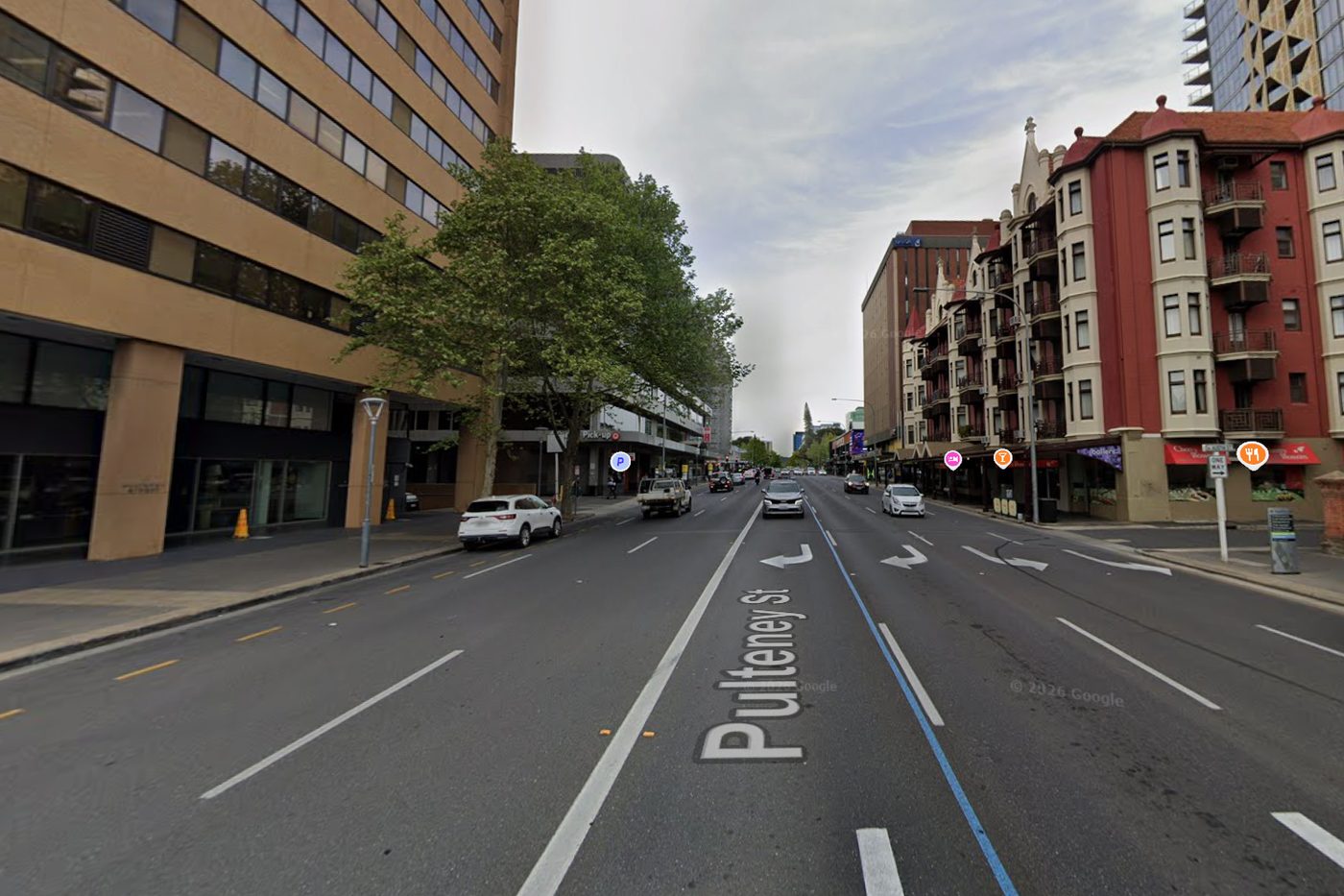
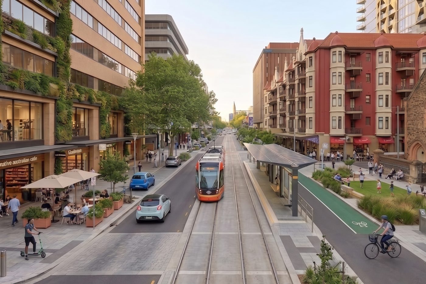
Pulteney Street in 1913, looking south from North Terrace: an electric tram in the middle of a wide unpaved street, overhead wires, a cyclist, pedestrians, and the Ruthven Mansions on the right. The same view in 2026: five lanes of asphalt, turning arrows, parked cars and a four-wheel drive, with the Ruthven Mansions still on the right. The same view reimagined for 2036: a tram back in the middle of the street, trees, bike lanes and wide footpaths, with the Ruthven Mansions on the right.
Pulteney Street, looking south from North Terrace, 123 years apart. Drive the tram: back to 1913, or on to 2036. Around 1913 a tram shared a wide street with cyclists and people on foot, and the first stage of the Ruthven Mansions, on the right, was barely a year old. In 2026 the mansions are still there; the tram, the people and most of the street are gone to five lanes of traffic. The 2036 picture puts the tram back. The c.1913 photograph (State Library of South Australia, B 8519) was colourised by Marina Amaral for the City of Adelaide's 2018 heritage exhibition in Rundle Mall. The 2036 image is an illustrative concept, AI-assisted, not a council proposal.
28 Dec 2036 Moseley Sq to City

2036: Two hundred years to the day

The tram from Glenelg is full before it leaves Moseley Square.

Sam gets a seat because a teenager stands up for him, which he pretends not to mind. He's 53. His knee has opinions now. Across the aisle his daughter Ivy, 18, is reading the screen above the doors, the way she did when she was eight: to the CITY.

It's two hundred years since South Australia's government was proclaimed, by tradition under a gum tree a short walk from where they boarded, and the whole state seems to be heading into town to celebrate.

This line has carried electric trams between the Bay and the city since 1929. It's the one tram line Adelaide kept, out of more than 20 routes the Tramways Trust ran between 1909 and 1958. MTT lines map Everything else about their day, and whether Sam's brother Dean is on this tram or circling the city looking for a park, depends on which 2036 they're living in.

And that depends on what we decide in the next couple of years.

10 years earlier September 2026

Same plans, two tracks

Receipt one September 2026
UPark Grote StTue 22 Sep 2026
Entry07:41
Exit16:05
Early bird, drive up$18.00
Paid byD. Trewin · ····4471
Dean's parking receipt. One of about 40 in the ute's door pocket, $720 worth.
Sam, Ivy and Dean are made up. The receipts from here on are a scenario; the plans in them are real. So are the prices.

Dean is 46 and has been a plumber since he was 17. He lives in Salisbury, in the house he grew up in, and drives the ute into the city three days a week because that's where the work is. His younger brother Sam, 43, moved to Plympton when Ivy was born and works for a state department on Flinders Street. He drives too. The car park under the building is part of the package.

The day the foot-traffic story runs, Dean sends it to Sam from a job on Gouger Street.

Tue 22 Sep 2026
Deanabc.net.au · CBD foot traffic down 12%some councillor reckons theres 54,000 car parks in town. where. did two laps of gouger this morning
SamThere's one under my building 😬
Deanyeah well i cant get a hot water unit up your lift
Deanmarket at 1? ivys shout

Ivy is eight and happy. Probably because she’s got a jam doughnut from Dough to keep her entertained while her dad talks to her uncle on Gouger Street. Ivy has been looking at the car park above the market, the one with the ramp that spirals up three floors. She interrupts her dad and uncle.

“Why is the car park bigger than the markets?” she asks.

Nobody has a good answer. Dean says it just is. Sam, who has read the council’s transport strategy for work, knows it’s 25 spaces for every 100 people who work in the city, and that Sydney manages on 12 spaces for every 100, but he says nothing. Forty-three years has taught Sam one thing about his brother: you don’t win arguments by quoting academia. City of Adelaide

The city Dean parks in

Change here for the heritage line THE HERITAGE LINE · 1838 → SEP 2026 THE STORY · 2028
Heritage lineDean's 40 receipts didn't start with him. His family has been keeping the city's paperwork since 1838. How this city got here

On 22 September the ABC reported that foot traffic in the city fell from an estimated 138.8 million visits in 2023 to 122 million in 2025. The Property Council blamed lost car parks and new bike lanes, and also said the council needed to get more people living in the city. Lord Mayor Jane Lomax-Smith pointed to working from home and a slow recovery from COVID, and said the city's parking compared well with other capitals. ABC

So let's talk about parking. In 2002 the Danish urbanist Jan Gehl's firm, working for the council and the state, estimated about 35,000 parking spaces in the northern half of the city centre. Similar-sized areas of other cities had far fewer: Perth 13,000, Lyon 12,000, Stockholm 8,000, Copenhagen 3,000. Gehl 2002 Nobody has counted all of it since. The council's consultants tally about 45,000 spaces open to the public and say the full total, including private car parks, is unknown. AECOM for the council, draft, Apr 2025 City councillor and urban planner Eleanor Freeman's own tally, published in September 2026, comes to about 54,000. Figures cited by the council put the city at 25 spaces for every 100 workers. Sydney has 12, Melbourne 14. City of Adelaide

Even though Adelaide has more parking per worker than Sydney or Melbourne, foot traffic in the city fell 12% in two years.

Whatever is keeping people away, it's hard to blame a shortage of places to park. Office vacancy sits at 16.3% (Property Council, July 2026). InDaily A council-commissioned study mapped 1,986 vacant or underused properties across the city and North Adelaide, about 30% of all properties in the CBD. InDaily

But here's what gives me hope. The plans already exist. Good people have done the work. Nobody has joined it up.

  • City Plan – Adelaide 2036. 50,000 residents by the bicentenary; a City Loop tram branching off the North Terrace line and running down West Terrace, along Sturt and Halifax streets and up the city's eastern edge; and a tram link to North Adelaide, possibly via O'Connell Street. City Plan
  • Hindley Street. A $50m upgrade with one-way traffic and wider footpaths, with construction from 2028. InDaily
  • Light Square. A master plan to make its western side green and car-free, the option backed by 79% of those who answered the council's survey. CityMag
  • O'Connell Street. A $15m redesign that keeps room down the middle for a future tram. CityMag
  • Halifax and Sturt Streets. Named, with West Terrace, for "Healthy Street" master plans in the council's Integrated Transport Strategy (July 2025). City of Adelaide

The street upgrades on Hindley and O'Connell are funded. The trams, the City Loop and most of the master plans are not. The state says it has no plans to extend the tram network. CityMag Meanwhile the $15.4bn north–south motorway is due to open in 2031. DIT

The Hindley Street revamp

Receipt two March 2028
Adelaide Metro · statementMar 2028
CardS. Trewin · ····2093
Trips, March22
Trips, February6
Most usedPlympton ⇄ City
Sam's Metrocard statement. He started catching the tram in the first week of the Hindley Street works, when the Currie Street detour added 20 minutes to the drive, and found he didn't mind.

The Hindley Street works start in autumn, as promised: two blocks dug up, one-way traffic, footpaths widened. InDaily Dean loses the loading zone he’s used for 11 years and parks in Light Square instead, which is still a roundabout with trees in it. He grumbles as he drags his gear into the plumbing job.

Mon 6 Mar 2028
Deanindaily.com.au · $50m Hindley Street glow-up50 million dollars. for two blocks of footpath
SamIt's the first two blocks
Deanof what

Sam doesn’t have an answer to Dean’s text yet. The council’s plan has a loop tram in it and the state has said it has no plans to build one. CityMag

Ivy is 10, and walks the block from the tram to Sam's office on the days she comes in after school. She has started counting the windows with nothing behind them. There are a lot. The council's own study found nearly two thousand vacant or underused properties. InDaily She's up to 41 on Flinders Street alone, and wants to know who's supposed to be in them.

The motorway opens

Receipt three August 2031
Ute · trip logWed 13 Aug 2031
DriverD. Trewin
Salisbury → Grote St31 min
Same trip, Aug 203047 min
Viathe new motorway
ParkedFranklin St, 3rd lap
Dean's trip log. A screenshot sent to Sam with no words. Just the two times.

The motorway opens on schedule. $15.4 billion, and for Dean, 16 minutes each way. DIT He is, for the first time in this story, completely right, and he enjoys it.

Wed 13 Aug 2031
Dean📷 Screenshot · 31 min / 47 min
Deantold you. build the road
SamWhere'd you park?
Deandont

Ivy is 13 and has a phone, which means she has a Metrocard, which means she has started going into town without either of them. Sam checks the family tracker app more than he'd admit. Hindley Street is finished and looks good on a Saturday night. On a Tuesday, Ivy reports, it's the same street with nicer bins.

This is the year our city’s two futures diverge.

In one future, the loop tram is costed, argued over, and dropped in the next budget.

In the other future, it wins funding on the argument that a city about to spend $15 billion getting cars to its edge could spend a fraction of that moving people around it once they arrive.

The Lift line 2036 A

A timetable for Duber

Receipt four · Lift line May 2033
Adelaide Metro · statementMay 2033
CardS. Trewin · ····2093
Trips, May2
Trips, May 202822
Sam's Metrocard statement. The motorway made the drive quicker for about a year. Then the traffic grew back, the way it tends to, and by then he'd stopped noticing the tram.

Ivy is 15, and her weekends are a timetable of lifts. Netball at Mile End, a friend’s place in Marion, a job at the Glenelg cinema she can get to by tram but not home from after 10pm. Sam feels like an Uber driver: Dad Uber – Duber.

The after-10pm rule isn’t Sam’s. It’s Ivy’s. The tram runs, but the stop is on a dark road with nobody on it, and she has done the walk once with her keys between her fingers and a friend on the phone the whole way, talking about nothing so the line stayed open. She doesn’t tell Sam that part. He’d only agree.

Sat 14 May 2033
Ivycan u get me at 9:30
SamCan you get the tram?
Ivynot from marion 🙃
SamYou’re right. It’ll be dark by then too.
SamOk. 9:30.

Dean’s in the city less. The jobs moved to the new subdivisions up north where the parking is free and the driveways are wide. When he does come in, he parks at the edge and walks, and grumbles that Light Square is still a roundabout. The master plan was finalised in 2029. The money never came.

A hatchback and a loan

Receipt five · Lift line December 2036
Finance · approvedMon 15 Dec 2036
ApplicantI. Trewin, 18
Vehicle2027 hatchback, 118,000 km
Amount$11,900
Term60 payments
GuarantorS. Trewin
Ivy's car loan. She passed her test in November. Every one of her friends did the same the week they turned 17, because the alternative is asking Dad until you're 25.

The tram runs the route it always has, up King William Street and along North Terrace to the Entertainment Centre. From the window Sam notices the gaps: shopfronts with paper in the windows, upper floors that have been dark since before Ivy was born. They get off at Rundle Mall and walk across to Hindley Street.

Hindley Street looks good, actually.

The upgrade finished in 2030: wider footpaths, trees, one-way traffic. On a Saturday night it’s busy. On a Tuesday lunchtime it’s a nicer street without many more people on it. Two blocks of good street, surrounded by everything that didn’t change.

Light Square is still a traffic island with trees in it. The master plan was finalised. The money never came.

The motorway opened in 2031, and for a while the drive in from the south was quicker. Then the traffic grew back, the way it tends to.

The city did get more people. Mostly students, in towers near the edges of the grid. But the streets between the towers never quite came alive, because there wasn't much to walk to, and nothing to carry you there except a car.

Ivy has the hatchback now, and the loan, and a fifth of her first pay going to it. She's on the tram today only because Sam asked, and because there was never going to be a park. Dean drove. He is somewhere near the Showgrounds, on his third lap, and will arrive in time for the fireworks and not the speeches.

Sam is 53. He has started thinking about the years when he won’t want to drive at night. In this Adelaide, that’s the year his world gets smaller. Ivy’s got bigger, and it cost her eleven thousand bucks.

The Loop line 2036 B

The loop of liveability

The loop tram opens

Receipt four · Loop line May 2033
Adelaide Metro · statementMay 2033
CardI. Trewin · student
Trips, May38
Most usedLoop · Morphett ⇄ Hurtle Sq
Charged$0.00 (city loop, free)
Ivy's Metrocard statement. 15, and going places on her own. Sam checks the family tracker app less than he did.

The loop tram opened in the spring. Netball is still at Mile End and the cinema is still at Glenelg, but the friend's place is now an apartment over a shop on Halifax Street, and half of Ivy's weekend happens inside the loop, on foot or on the tram, without a lift from Duber.

The shops along the loop streets have been growing a floor or two of flats above them since the line was announced. Nothing tall. Just the empty upper storeys filling in, the way the empty ones on Halifax Street did first.

She takes the tram home after 10pm now, too. Not because anyone told her it was safe, but because the stop is outside a bar and a bakery that are still open, the footpath has people on it, and the next tram is never more than a few minutes away. The walk with keys between her fingers is somebody else’s story. Sam still checks the app. Less.

Sat 14 May 2033
Ivycan u get me at 9:30
SamCan you get the tram?
Ivyyep 🚊
Ivyill text you when im two stops away for a quick pickup?
Samsounds good xo

Dean's ute has a sticker on the windscreen that lets him into the loop streets between 6am and 11am, when the deliveries happen. He fought the permit for a year, and then found that a street with no through traffic and a guaranteed loading bay is the easiest street he's ever worked on.

Thu 9 Jun 2033
Deandone 3 jobs on halifax before 11. no circling. bay right out front
SamSo the permit's fine then
Deandont tell anyone i said that

Dean’s first tram trip

Receipt five · Loop line December 2036
Adelaide Metro · tapSun 28 Dec 2036
CardD. Trewin · ····0417
OnMoseley Sq, 09:52
Farebicentenary, free
Trips on this card, ever1
Dean's tram card. Ivy bought it for him. He said the tram was full and the seats were hard and he'd have driven if there was anywhere to put the ute, and then he stayed for the speeches.

The Glenelg tram is the same. What's different is where it goes. At Rundle Mall, Sam and Ivy stay on. The council's first City Loop ran out on West Terrace and Hutt Street. It was redrawn a block in on each side, onto the streets where the new homes, shops and passengers would be, so the tram now runs the loop of liveability itself: off North Terrace, down Morphett Street, along Sturt and Halifax, and back up Pulteney. It opened a few years ago. The North Adelaide line now runs up O'Connell Street, over a rebuilt Adelaide Bridge, down the middle of the street the council kept clear for it back in 2027.

They get off at Morphett Street, because Ivy wants to walk the loop instead of riding it.
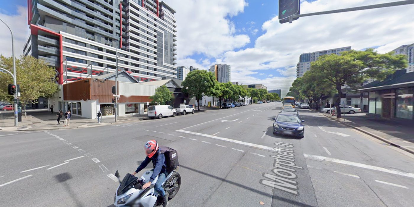
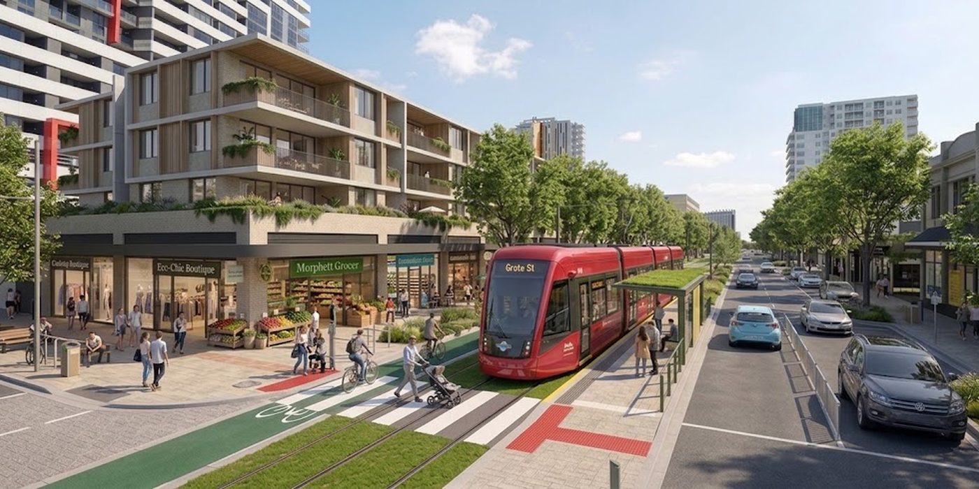
Morphett Street at Grote Street today, looking north: five lanes of traffic and turning lanes, traffic lights, an apartment tower and a row of low shops. The same corner reimagined: a red tram at a Grote St stop on a grassed track, a green bike lane running along the shopfronts of a grocer and boutiques with homes above, a zebra crossing with tactile paving, and one traffic lane each way on the far side. Today2036 B
Morphett Street at Grote Street, looking north. Where Sam and Ivy step off. Today: five lanes, turning lanes and traffic lights. In 2036 B: the tram stop sits outside the shops, and the bike lane and the tram run along the shopfronts, with the cars kept to the far side. Illustrative concept, AI-assisted. Not a council proposal.

From the stop they walk a couple of blocks north to Light Square. Its western side is green and car-free, as the master plan proposed. There are kids on the grass where the Morphett Street slip lane used to be.

They cut through the middle first. Hindley Street went further than the council's 2026 plan: it's pedestrian now, like Rundle Mall, so one car-free spine runs from Morphett Street to Pulteney Street. It isn't a nicer street on its own any more. It's the heart of the loop. The 17 convenience stores that lined it in 2026 have mostly become other things.

North Terrace is the loop's top edge, where it meets the Glenelg line and the North Adelaide line. The loop tram runs the other three sides. Step off at any stop and you're already on it.

Just past the loop's east side, Rundle Street used to close to cars for Fringe weekends. Now it's like that every weekend, and weekdays aren't far off.

Pulteney Street runs down the loop's east side, from North Terrace past Hindmarsh Square to Hurtle Square, with the tram down the middle. Shopfronts at street level, apartments above.

And Halifax and Sturt, the healthy streets the council named back in 2025, have trees, slower traffic, homes over shops, and the loop tram running along them. This is where most of the new residents live. Families, not just students, because they can walk to a school, a park and a tram.
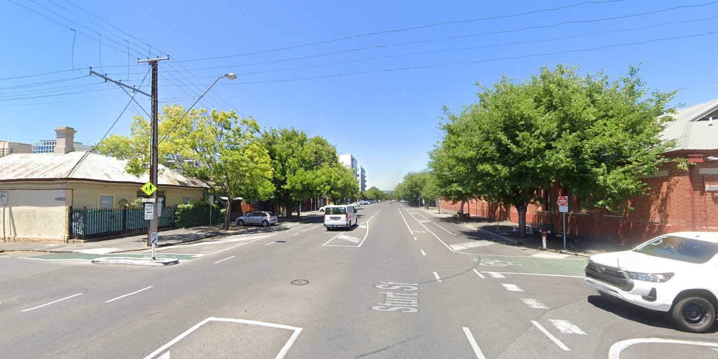
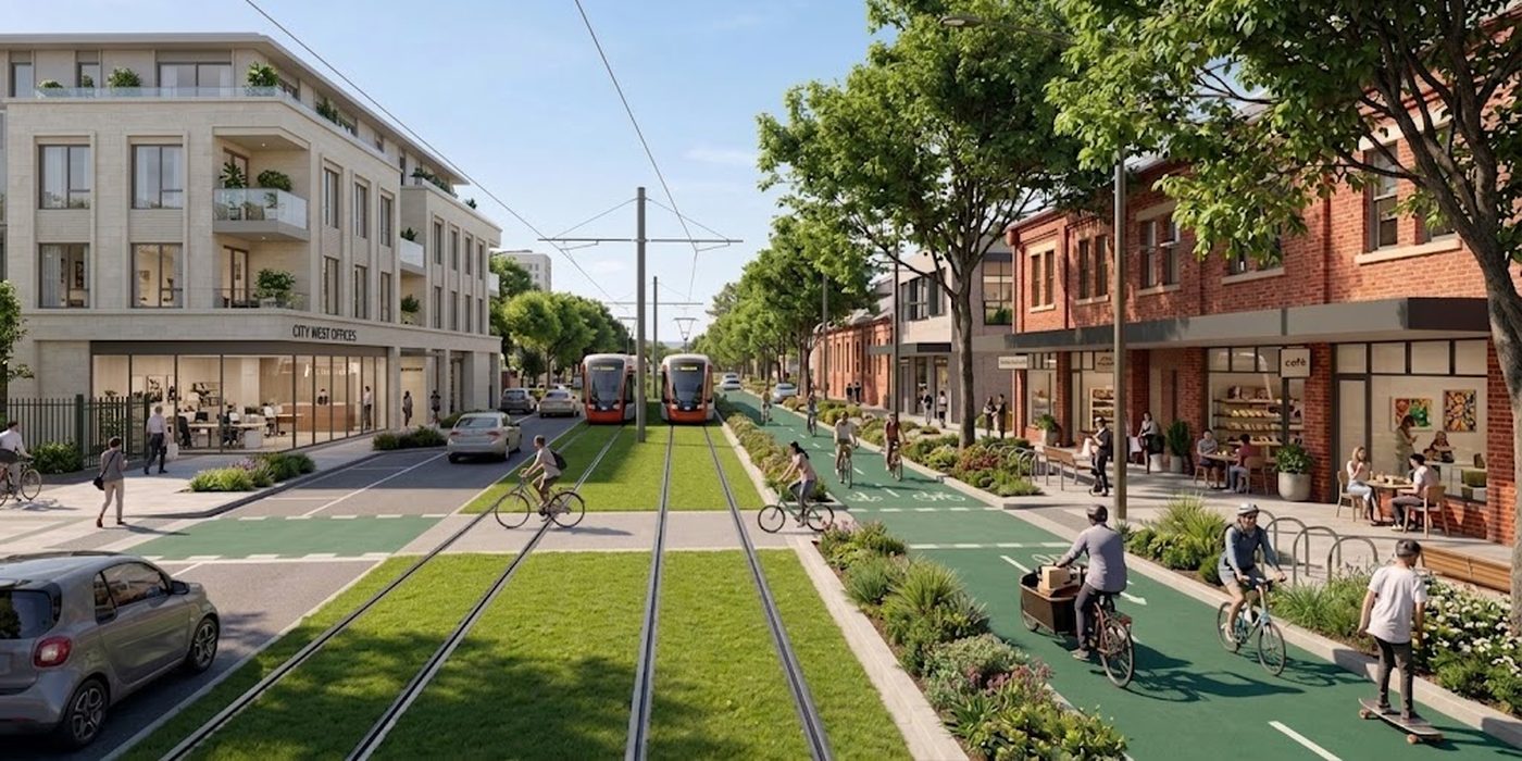
Sturt Street at Russell Street today, looking east: four lanes of asphalt, painted islands and turning arrows, a school-zone sign, street trees, and old brick and stone buildings on both corners. The same street reimagined: two trams on a grassed track down the middle, green protected bike lanes, street trees and garden beds, and cafes and shops at the foot of the old brick buildings. Today2036 B
Sturt Street at Russell Street, looking east. One of the streets the council named for a "Healthy Street" master plan in 2025. Today: four lanes of asphalt, painted islands and a school-zone sign. Tomorrow: the loop tram on a grassed track, protected bike lanes, street trees, and cafes and homes in the old brick buildings along the footpath. Illustrative concept, AI-assisted. Not a council proposal.

Morphett Street closes it, tram and all, past Whitmore Square and back to Light. Four of the five squares in Light's southern grid, joined by an easy hour's walk.

The city's car parks haven't vanished. Most of them are still there, in the big parking stations near the edges of the grid. What changed is the streets inside the loop: loading in the mornings, disabled parking kept and added, visitors first, and the free two-hour shuffle gone.

Ivy is 18 and keen for a big one. The city is buzzing. People are dressed up for the bicentenary, roads are closed, restaurants have spilled out onto the streets, and everyone is walking to events all over town.

It reminds Sam of the Fringe, when the East End closes to traffic and car parks become alfresco dining.

Sam isn’t worried about Ivy drink-driving, either, because Ivy doesn’t have her licence. Half her friends don’t. Nobody told them not to; it just isn’t something their lives need. They’ve been getting around the city without Mum and Dad (Muber and Duber) since they were 15. The $11,000 that would have paid off a hatchback is the start of a deposit on an apartment in the city, near her friends and the uni she starts next year.

And Sam, at 53, is happy. He’s not up for a big one like Ivy, and he’s quietly stoked he didn’t have to drive in and won’t have to drive home in the dark.

His knee isn’t arguing with him right now, as he lengthens his step to catch up with his daughter. But he knows there’s always a tram stop nearby, where he can opt out of all this fun and ride home to the ’burbs.

Which 2036 do you want?

Epilogue back to now

What it would take

None of this needs a new idea. It needs about six decisions, and most of them are already half-made.

45%of the high-potential idle land within five minutes of a tram

Nearly half of it is already within five minutes of a tram, and it is still idle. Track on its own hasn't done it.

3.6 km of new loop track, down Morphett, along Sturt and Halifax and back up Pulteney. On North Terrace the loop runs on today’s line, so trams keep circling the city. Paired with a homes program on every idle site the loop and today's line reach.

Over Adelaide Bridge, up King William Road past the Oval and round Brougham Place, then up O'Connell Street to Barton Terrace.

A branch from the Oval stop, up Sir Edwin Smith Avenue and along Melbourne Street, to the last cluster of idle sites north of the river.

High + moderate sites in reach
41%
New track, this phase
—
New track, in total
0.0 km
The five-minute city. The council's own map of long-term vacant and underutilised sites, with a tram corridor of 400 m, about five minutes' walk, either side of each line. Inside it, idle sites fade as the line reaches them. The percentages are shares of the red area on the map, not a count of properties; the fade marks the sites a tram-and-homes program would go after first, not a forecast; the routes are schematic, not council or state alignments. City of Adelaide, 2026 InDaily City Plan 2036
01Fund the loop tramNot funded

Fund the loop tram and the new Adelaide Bridge.

The council's City Loop is the plan on the table; running it on the loop of liveability instead is a design choice, not a different project. Estimates quoted by one councillor put the loop at "north of $500 million". InDaily The heritage-listed Adelaide Bridge would need upgrades estimated at more than $60m to carry trams. CityMag For scale, the north–south motorway costs $15.4bn. DIT

Why a block in from West Terrace? The council's 2016 Adelaide Design Manual treated the terraces as the city's green edge onto the Park Lands, noting they "often have a low frequency of public transportation services". A loop one block in runs past the homes, shops and four of the five southern squares instead. Adelaide Design Manual · Terraces

The loop only pays if the homes come with it. When Canberra's Auditor-General checked the light rail business case, the transport benefits on their own returned about 49c in the dollar; the case stood up on the land-use side, the roughly 6,100 homes since approved or proposed along the corridor. ACT Auditor-General, 2016 ACT Government, 2024 Planners call that transit-oriented development. In a square mile that is already one walkable catchment it runs the other way: put the tram past the empty upper floors and the squares, and decision 03 pays for decision 01. Newcastle built the tram and stopped there. It is the least-used line in the country. Daniel Bowen

02Build the consulted plansPart funded

Build the plans we've already consulted on.

Hindley Street, Light Square, O'Connell Street, and the healthy streets on Halifax and Sturt. The community has had its say on most of them.

03Idle buildings as homesMapped

Treat the 1,986 idle buildings as the housing supply they are.

From 1992 Melbourne's Postcode 3000 program used incentives and conversions to bring people back, and the number of homes in the central city rose from 736 in 1992 to about 9,900 in 2002, while weekday evening foot traffic almost doubled. Places for People 2004

Start with something the council has already run: in 2016 it matched shopfront upgrades 50:50, from $1,000 to $6,000, and 18 businesses took it up. Scale that up for ground floors that open back onto the street, and start on the loop streets, where the tram in decision 01 needs them most. Adelaide Design Manual

04Manage our car parksDebated

Manage the car parks we have, instead of adding more.

Visitors, loading, disabled parking and residents first, as Cr Eleanor Freeman argues. It's not a war on parking. It's using what we've got.

05Pair every tram with homesNot started

Pair every tram with homes.

Canberra's light rail came with rezoning along Northbourne Avenue: about 6,100 dwellings approved or proposed along the corridor since 2016, ACT Government, 2024 and unimproved land values in the corridor up 35% between 2011 and 2018, against 22% across the ACT. ACT Gov

Newcastle built a short, 2.7km line and carries the fewest passengers of any tram line in the country, about 0.9 million a year. Daniel Bowen

06Back the businessesNot started

Look after the businesses on the street while it's built.

Sydney paid about $31m to up to 154 businesses along its light rail, and a traders' class action still went all the way to the High Court, which found Transport for NSW liable in December 2025. ABC Parramatta's Church Street traders had no compensation scheme. ABC

Adelaide can do better: stage the works, and compensate from day one.

Status as at September 2026 · tap a line for the detail

What it would cost, and what comes back

A rough price on the tram, set against the motorway and against what the homes along it could return. These are estimates, not costings.

8%

All three tram phases, with the trams and help for the businesses along them, come to about $1.3 billion: roughly eight cents for every dollar going into the $15.4 billion north–south motorway.

And what comes back?Up to $4.6bn in new homes and land along the lines, and around half the cost back to government by 2036.
$1.3bnto build the loop, O'Connell St and Melbourne St8% of the motorway
$0.5–0.85bnback in GST, stamp duty, rates and land tax by 2036around half the cost
$3–4.6bnin new homes and higher land values along the linestwo to three times the cost
2026–28Commit and design. Land values start to move.
2028–31Phase 1, the loop. First homes on idle sites.
2031–33Phase 2, O'Connell St and the bridge.
2033–35Phase 3, Melbourne St. Home building peaks.
20364,000–6,000 new homes. Rates and land tax keep coming; the public side breaks even in the 2050s.
The breakdown, phase by phase
WhatTrackEstimateIdle land in reach
Phase 1 · the loop3.6 km$600m$400m–$850m45% → 74%
Phase 2 · O'Connell St, incl. Adelaide Bridge1.9 km$350m$270m–$500m→ 86%
Phase 3 · Melbourne St1.7 km$260m$190m–$400m→ 90%
About 13 new trams$100m
Compensation for businesses along the works$30m$20m–$40m
Total7.2 km~$1.3bn~$0.9bn–$1.8bn

These are estimatesThey are not a business case or an engineering costing. The loop reuses today’s North Terrace track, so only 3.6 km of it is new. Each phase is its length multiplied by what comparable Australian tram lines have actually cost per kilometre: from Adelaide's own 2018 North Terrace extension, adjusted for inflation, at the low end, to the Gold Coast's Stage 3 at the high end. The range is wide because tram projects often run over, with the Gold Coast's cost more than doubling. The figures leave out depot expansion, land, and the cost of running the service. The compensation line assumes about a third of the 450–600 street-front businesses on the routes qualify for hardship payments. The returns assume about 4,000–6,000 homes are built on idle sites by 2036, which depends on closing the funding gaps the council's own study found; GST goes to the national pool first, so South Australia's share is smaller. The idle-land shares come from the map above and are measured by map area, not property count.

Benchmarks: Adelaide's 2018 extension, 1.26 km budgeted at $80m and projected to reach $124m ABC; Gold Coast Stage 3, 6.7 km, $1.55bn against $709m first estimated ABC; Canberra Stage 2A, 1.7 km, a $577m contract Region; North Adelaide line, $259m in 2018, and Adelaide Bridge, more than $60m CityMag; Sydney traders' compensation ABC; land value uplift from light rail Murray; idle sites and funding gaps City of Adelaide, 2026; motorway DIT

Who this is hard for

A fair story names the people it asks the most of.

Everyone on this platform is asked for something. Tap a passenger to see what, and what the plan gives back.

Here’s the thing… cars will always have a place in Adelaide. The question is whether they get every place. Adelaide doesn’t need to become Copenhagen. It needs to become Adelaide again, with better housing, electric trams, and the dunny indoors. Light gave us the plan. The council has the target. Good work is on the table. What’s missing is the decision, and the follow-through.

How we got here 1836–2017

Two hundred years, five Trewins

Sam and Dean didn't get their receipts by accident. Five generations of their family were handed the city's decisions one at a time, and kept the paperwork.

People living in the City of Adelaide, 1836 to 2036: near zero in 1837, about 43,000 in 1915, 35,000 in 1947, 14,000 in 1972, a low of about 12,000 in the 1990s, 25,000 in 2021, 30,173 in 2025, and a council target of 50,000 for 2036. Five points mark five generations of one family: William 1838, Ada 1915, Frank 1958, Lyn 1972, Sam 2002. Select a point to read that chapter. 43,000 14,000 12,000 30,173 50,000 target 2036 1838William 1915Ada 1958Frank 1972Lyn 2002Sam
People living in the City of Adelaide, 1836 to 2036: about 43,000 in 1915, 35,000 in 1947, 14,000 in 1972, a low of about 12,000 in the 1990s, 25,000 at the 2021 census, 30,173 in 2025, and the council's 50,000 target for the bicentenary. ABC ABS ABS 2025 The line between those points is drawn, not measured. The five points are five generations of one made-up family. Tap a point to jump to that chapter.
1836–1900 William

The planned city

Colonial Land Office · town acreAdelaide, 1838
AcreNo. 529, Sturt Street frontage
PurchaserW. Trewin, labourer
Occupiedfrom the winter of 1838
William Trewin's land receipt. He's 22 and off a ship from Plymouth. He walks everywhere, because there is nowhere else to go yet.

The Trewins are fiction: one family, invented to carry two hundred years of real dates, real numbers and real plans. All of it is documented, and every fact links to its source so you can check it as you go.

William lands the year after the proclamation, works on the survey gangs, and puts what he has into a town acre on the southern edge of Light's grid, where Sturt Street runs out to the Park Lands. He'll live and die within a mile of it. His great-great-great-grandsons are Sam and Dean.

South Australia's colonial government was proclaimed at Holdfast Bay on 28 December 1836, on Kaurna Country. Within days Colonel Light had chosen the site for Adelaide, a few miles inland. The Kaurna people had lived on these plains for thousands of years before that. The colonial city's two hundred years are a short chapter in a much longer story.

In 1837 the Surveyor-General, Colonel William Light, laid out the city: a grid of generous streets, five public squares in the south and a sixth in North Adelaide, and a continuous belt of Park Lands wrapped around the whole thing. It's still the only Australian city completely surrounded by parkland, and the Park Lands and city layout are on the National Heritage List. City of Adelaide

Remember the southern squares. Four of the five sit on the loop this story ends with.

The first horse trams ran on 10 June 1878, from the city out to Kensington Park. By the early 1900s private companies were running about 80km of horse-tram routes. Wikipedia

1900–1945 Ada

The tram city

Municipal Tramways Trust · section fareSturt St, 1915
RouteSturt St to Victoria Sq
Fare1d
Classadult, single
Ada Trewin's tram ticket. William's granddaughter runs the house on Acre 529 as a boarding house: 11 lodgers, none of them with a car. She keeps the tickets in a jar for the children to count.

Ada is 35 in 1915, her husband away at the war, and the busiest person on Sturt Street. Her lodgers work at the West End brewery, the railway yards and the boot factories, and walk or ride the tram to all of them. The city she runs her house in has 43,000 people in it. She is Sam and Dean's great-grandmother.

In 1906 Parliament created the Municipal Tramways Trust, which in 1907 bought out the horse-tram companies. The first electric trams ran on 9 March 1909. Wikipedia

Around 1915, about 43,000 people lived in the city, counting North Adelaide. They lived in cottages and boarding houses and above the shops they ran, and many worked in factories in the city or on its fringe. CityMag It wasn't paradise. The housing was crowded and often criticised, and as Lord Mayor Jane Lomax-Smith put it in 2025, "we're never going back to that" dunny in the back garden. ABC

But the city was full. People walked, or they caught the tram.

The network kept growing until 1931, when it peaked at about 133 route kilometres. Year Book Australia 1932 In 1937 electric trolleybuses, running on overhead wires, joined the trams. Wikipedia And at the wartime peak, in 1943–44, the Municipal Tramways Trust's trams, trolleybuses and buses carried about 95 million passengers. Year Book Australia 1944–45

In the war years the average Adelaidean rode a Tramways Trust tram, trolleybus or bus about 250 times a year.

Map 1952 See the network for yourself: the Municipal Tramways Trust's own route map from 28 May 1952, six and a half years before the last street tram.Public domain, via the National Library of Australia and Wikimedia Commons

Something else was arriving, though. By 1921 South Australia had more motor vehicles per person than any other state, a lead it kept until the mid-1960s. SA History Hub

1945–1975 Frank and Lyn

The car state

Deposit receipt · FC Holden SpecialSat 22 Nov 1958
PurchaserF. Trewin
Deposit£150
Balanceon terms, 36 months
Colourtwo-tone, blue over cream
Frank Trewin's car deposit. Ada's son puts the deposit down on the Saturday morning, then rides tram No. 269 from Victoria Square to Cheltenham that night, because it's the last one, and it's what his mother would have done.

Frank is 38. He's spent the war years in a Tramways Trust uniform, one of the people who carried those 95 million passengers, and he's watched the Trust's own board plan the trams out of existence. He doesn't argue with it. He has two kids and a job at Woodville, and the car he helped build is the future everyone can see. He is Sam and Dean's grandfather.

After the war, South Australia doubled down on a strategy that had begun in the late 1930s, and it was a deliberate one.

Premier Thomas Playford, who drove that strategy harder than anyone, built the state's economy on manufacturing, with cars and household appliances at its heart. SA History Hub Holden had been building car bodies at Woodville since 1923, and in 1948 Woodville built the bodies for the first Holden, the 48-215, launched at Fishermans Bend in Melbourne. Wikipedia In 1955 Playford opened Elizabeth, a new satellite city to the north, built around factory jobs. Holden later opened a plant there too. Wikipedia

If your state's economy builds cars, you build a state for cars. Between 1948 and 1964, vehicles per 1,000 South Australians went from 162 to 360. SA History Hub By 2021 it was about 835 per 1,000. ABS

The network entered the 1950s worn out and losing money, and in 1953 a new, government-appointed Tramways Trust drew up a 10-year plan to replace every tram line with diesel buses. The last street tram, No. 269, made its final run between Victoria Square and Cheltenham on the night of 22 November 1958. Only the Glenelg line survived, largely because it ran on its own track and didn't get in the way of cars. Railtram The trolleybuses followed them out in 1963. Wikipedia

Here's the part that stings. Melbourne faced the same fashion for scrapping trams in the same decade… and kept its network.

It helped that Melbourne had wider streets, sounder finances, more track separated from traffic, and a tramways chairman who refused to budge. Spearritt

The city emptied. Between 1947 and 1972 the number of people living in it fell from about 35,000 to about 14,000. ABC

Land agent · settlement statementFri 4 Aug 1972
VendorL. Trewin
Sold412 Sturt St, Adelaide
Purchased3-bed brick, Salisbury
Settledsame day
Lyn Trewin's settlement statement. Frank's daughter is 24 when she sells the house Ada ran, the year the city's population falls to about 14,000. She'll live in the Salisbury house for the rest of her life, and so will one of her sons.

Lyn isn't fleeing anything. The city in 1972 is offices and car parks and a few old boarding houses like hers, and Salisbury has a new school, a yard, and Frank's plant at Elizabeth 10 minutes up the road; he moved there when Holden opened it. The move is the sensible one. She is Sam and Dean's mother, and Dean still lives in that house.

Then, in 1968, came a plan that would have taken the last tram too. The Metropolitan Adelaide Transport Study, known as MATS, proposed about 90 to 98km of freeways, a rail subway under King William Street, and giving the Glenelg tram's route to a freeway. The Noarlunga Freeway alone would have meant compulsorily acquiring up to 3,000 properties, including 817 homes. Wikipedia The city itself was already being cut: by 1962 the Tavistock Hotel and rows of workers’ cottages had been demolished to push Frome Street through as a north–south artery. The wrecking stopped at Carrington Street after the historian Hugh Stretton and others objected. InDaily Adelaideans pushed back hard, and in 1970 the new Dunstan government shelved MATS, later promising no freeways in built-up Adelaide for at least 10 years. It kept the corridors it had already bought, though. ATRF

1976–2017 Sam

The pushback, and the hangover

The seventies showed what Adelaide can do when it wants to. On 1 September 1976 Premier Don Dunstan opened Rundle Mall, one of the first streets in Australia closed to cars and handed to people. ABC 50 years on, it's hard to picture it any other way.

But the big transport choices kept leaning away from rail. The north-east got the O-Bahn in 1986: a guided busway, only the second modern one in the world after Essen's, built instead of the light-rail line that had been planned for the corridor. DIT In 1980 the Tonkin government committed to selling off the MATS land, and in June 1983 the Bannon government abandoned the last corridor, the North–South. ATRF

A bay with his name on it

Staff parking permitFlinders St, Feb 2002
Bay212, level 2
HolderS. Trewin
Charge$0, salary packaged
Sam's parking permit. 19, first real job, first car, and a bay under the building that comes with the desk. It's the year Gehl's people estimate 35,000 spaces in the top half of the city and call it a lot.

Sam drives in from Salisbury on the Main North Road every day for six years. Nobody suggests the train. There's a bay with his name on it, and Dean, already on the tools, is doing two laps of Gouger Street looking for one without.

The tram comes back

TransAdelaide · MetroticketSun 14 Oct 2007
OnVictoria Square, 10:20
OffCity West, end of the line
Farefree, city section
Sam's tram ticket. 24, and on the first Sunday a tram runs past Victoria Square since 1958, he rides it to the new end of the line and back. Twice. It costs nothing, which is the part Dean finds hardest to believe.

Then, slowly, the tram came back. On 14 October 2007 the Glenelg line was extended from Victoria Square up King William Street and along North Terrace to City West, with free travel inside the city. In 2010 it went on to the Entertainment Centre, and in 2018 east along North Terrace to the Botanic Garden. Wikipedia

In 2016 the state government went further with AdeLINK, a tram network radiating out from a city loop. After the 2018 election, only the East End sections already under construction were finished. DIT

And on 20 October 2017 the last Holden rolled off the line at Elizabeth, and car manufacturing in Australia ended. ABC

The economic reason for building South Australia around the car was gone. The car-shaped city stayed.

UPark Grote StTue 22 Sep 2026
Early bird, drive up$18.00
Paid byD. Trewin · ····4471
Dean's parking receipt, again. 24 years after Bay 212, the family is still paying to park a few blocks from where Ada's lodgers walked.
Last a confession

A city built for 15 kilometres an hour

Before we go back to the story, a confession. I've probably spent more time than most people using Adelaide's streets as a transport system.

In 2014 I launched EcoCaddy: electric-assist trikes carrying two passengers at 15 to 20km/h through the CBD's bike lanes. Later, during COVID, we hauled up to 800kg of food waste at a time out of the city's busiest restaurants, cafes and supermarkets… by trike.

Here's the thing I learned at 15km/h. This city is ridiculously easy to get around if you're not in a car. It's flat. The streets are wide. The Park Lands are a few minutes from anywhere. Colonel Light gave us a city built for exactly the speed we've spent 70 years designing out of it.

Back onto the story line THE STORY · SEP 2026 → THE HERITAGE LINE · 1838–2026
That's the city Sam and Dean drive into every day, and the one Ivy is about to inherit. Which brings us to September 2026.

Change hereBack to the story · Sep 2026

Evidence for the planners

The evidence

Everything the story rests on, in one place. Rows in red are the moments when a different choice was plausible.

YearWhat happenedSource
1837Light's plan: a grid of wide streets and squares, wrapped in Park LandsCity of Adelaide
1878First horse trams, city to Kensington ParkWikipedia
1909Electric trams start under the public Municipal Tramways TrustWikipedia
1915City of Adelaide population peaks at about 43,000 (including North Adelaide)ABC
1921SA leads Australia in motor vehicles per personSA History Hub
1929Glenelg line converted to electric tramTramway Museum
1931Tram network peaks at about 133 route km (82.84 route miles)Year Book Australia 1932
1937Electric trolleybuses startWikipedia
1943–44Tramways Trust patronage peaks at about 95m trips a yearYear Book Australia 1944–45
1947–76City population falls from about 35,000 to under 14,000 (the low came in the 1990s)ABC
1948Woodville builds the bodies for the first Holden, the 48-215Wikipedia
1948–64Vehicles per 1,000 South Australians rise from 162 to 360SA History Hub
1953New government-appointed Tramways Trust plans to replace all trams with busesRailtram
1955Elizabeth founded, planned around factory jobsWikipedia
1958Last street tram. Only the Glenelg line survivesRailtram
1962Frome Street pushed through; Tavistock Hotel and workers’ cottages demolishedInDaily
1963Trolleybuses replaced by diesel busesWikipedia
1968–71MATS freeway plan, backlash, shelved, then a 10-year freeway freezeATRF · Wikipedia
1976Rundle Mall opensABC
1986O-Bahn busway opens, chosen instead of light railDIT
2002Gehl's firm estimates about 35,000 parking spaces in the northern half of the city centreGehl
2007–18Tram extended through the city and along North TerraceWikipedia
2016Council’s Adelaide Design Manual puts pedestrians, cyclists and public transport “on equal footing with vehicles”Adelaide Design Manual
2016–18AdeLINK tram network proposed, then droppedDIT
2017Holden closes at ElizabethABC
2021Census counts 25,026 people in the City of AdelaideABS
2021835 motor vehicles per 1,000 South AustraliansABS
2024City Plan sets 50,000 residents by 2036City Plan
2025Estimated city visits fall to 122m a yearABC
2025Council’s consultants tally about 45,000 public parking spaces; total supply “unknown”AECOM
2025Integrated Transport Strategy names Halifax, Sturt and West Terrace for Healthy Street master plansCity of Adelaide
2025City population estimated at 30,173ABS
20261,986 vacant or underused properties mapped; office vacancy 16.3%InDaily
2026$50m Hindley Street upgrade announced, works from 2028InDaily
2026$15m O’Connell Street redesign keeps the median for a tram; state has “no plans” to extend the networkCityMag
2031$15.4bn north–south motorway due to openDIT

Other cities that tried

CityWhat they builtWhat happenedThe honest caveat
Canberra12km light rail plus rezoning, 2019, $675mBeat its 2021 weekday patronage target in most months before COVID. About 6,100 homes approved or proposed on the corridor since 2016. Land values up 35% (2011–18) against 22% ACT-wide. Transport benefits alone returned about 49c in the dollar; the homes made the case (ACT Auditor-General)A new corridor through mostly government land, with the housing count starting before the line opened. An Adelaide loop runs through fragmented private land
Gold CoastG:link, about 27km, 2014–202613.8m trips in 2024–25, its highest yet. Home values near stations 2–26% higher (Yen et al., 2018)Retail in Surfers Paradise fell, though a 2024 study found the light rail wasn't the cause
MelbournePostcode 3000 housing incentives, from 1992Central-city homes up from 736 (1992) to about 9,900 (2002); evening foot traffic almost doubledMelbourne kept its tram network when other cities scrapped theirs
SydneyLight rail and the George St boulevard, 2019–20Australia's busiest tram routes. People sitting and standing doubled at two surveyed spots on George St SouthCost rose from $1.6b to over $3.1b. Traders sued in 2018; the state later paid compensation, and the High Court found Transport for NSW liable in December 2025
Newcastle2.7km light rail and a rail corridor turned into public space, 2019About 3,000 trips a weekday (January 2024)The least-used tram line in the country. Traders have been preparing a class action
GeelongGovernment offices moved to the CBD, no light railCentral Geelong jobs up more than 30%, 2011–17Yet in 2024 about 25,000m² of offices and 20,000m² of shops sat empty

Why "healthy streets" isn't just a nice name

One more number, because it's the one I can't shake. Modelling done for Preventive Health SA estimates that, without action on childhood obesity, South Australians born in 2023 could lose around seven months of life expectancy against the pre-pandemic baseline. Closing that gap would take a cut of about a quarter in childhood obesity. Preventive Health SA, 2024 Over the same decades, Australian kids stopped walking and riding: in Victoria, the share of students walking to school or study fell from 49% in 1970 to 20% in 1994, while the share driven rose from 16% to 52%. SA Dept for Infrastructure and Transport Pooling studies from New South Wales, South Australia and Victoria, Active Healthy Kids Australia estimated that children's active travel to school fell by about 42 percentage points between 1971 and 2013. AHKA, 2015

I'm not claiming the car caused any of that on its own. But a four-year study of 822 Adelaide adults found that among people who exercised at least 150 minutes a week, full-time car commuters put on about 1.5kg more than people who didn't commute by car. Across everyone the gap was smaller and not statistically clear. Sugiyama et al., 2013

A street you can walk, ride or catch a tram along isn't a lifestyle choice. It's one of the cheapest public health programs a city can run.

All sources

Every link in the story, grouped by chapter.

  1. ABC News, CBD foot traffic decline exposed in council data, 22 Sep 2026
  2. City of Adelaide, Motor Vehicles and Parking discussion paper, 2024
  3. AECOM for City of Adelaide, Integrated Transport Network Report (draft), Apr 2025
  4. Gehl Architects, Public Spaces and Public Life: City of Adelaide, 2002
  5. ABS, Regional population, 2024–25
  6. ABS, 2021 Census QuickStats, Adelaide (C)
  7. InDaily, Almost two thousand idle city buildings mapped, 1 Sep 2026
  8. City of Adelaide, Assessment of Long-term Vacant and Underutilised Sites for Housing, City Planning, Development and Business Affairs Committee, 1 Sep 2026 (Figure 1, the base map for the five-minute city)
  9. City of Adelaide, Cr Eleanor Freeman
  10. City of Adelaide, City Plan – Adelaide 2036, 2024
  11. City of Adelaide, Integrated Transport Strategy, July 2025
  12. InDaily, Hindley Street glow-up, 14 Sep 2026
  13. CityMag, Long road for Light Square upgrade, 12 Feb 2025
  14. CityMag, North Adelaide tram calls in multimillion-dollar plan, 16 Sep 2026
  15. InDaily, City tram extension and population boost wanted by 2036, 4 Sep 2024
  16. SA Dept for Infrastructure and Transport, River Torrens to Darlington
  17. City of Adelaide, Adelaide Design Manual, 2016: Introduction, Street Design, Building Frontages, archived website
  18. City of Adelaide, Adelaide: a National Heritage icon
  19. City of Adelaide Archives, Street to Town Acre index
  20. ABC News, Adelaide CBD population target of 50,000, 2 Aug 2025
  21. CityMag, The road to 50k, 27 Oct 2025
  22. Wikipedia, Trams in Adelaide and Trolleybuses in Adelaide
  23. Commonwealth Year Book, 1932 and 1944–45
  24. Municipal Tramways Trust, route map, 28 May 1952
  25. W. Adams, MTT electric lines 1909–1958 (Google My Maps)
  26. Tramway Museum St Kilda, South Australian trams
  27. Railtram, Adelaide Tramways
  28. SA History Hub, Motor vehicles and Industrialisation
  29. Wikipedia, Holden Woodville Plant and Elizabeth, South Australia
  30. ABS, Motor Vehicle Census, 31 Jan 2021
  31. P. Spearritt, Why Melbourne kept its trams, 2014
  32. Wikipedia, Metropolitan Adelaide Transport Study
  33. D. Washington, InDaily, Frome St: the street that never was, 2014
  34. Nairn, ATRF, MATS retrospective, 2021
  35. ABC News, Rundle Mall turns 40, 2016
  36. DIT, The O-Bahn turns 40, 2026
  37. Wikipedia, Tramways revival in Adelaide
  38. DIT, AdeLINK multi-criteria assessment summary
  39. ABC News, Holden closing for the last time, 20 Oct 2017
  40. ACT Government, Light Rail Benefits Realisation Snapshot, 2020, and Light Rail Five Years On, 2024
  41. ACT Auditor-General, Report No. 5 of 2016
  42. Yen et al., Land Use Policy, 2018; Kamruzzaman, Journal of Transport Geography, 2024
  43. Gehl Architects and City of Melbourne, Places for People 2004
  44. ABC News, High Court light rail class action, 17 Dec 2025, and Parramatta light rail businesses, 30 Jan 2023
  45. Transport for NSW, Places to Love: George Street; NSW Audit Office, CBD and South East Light Rail follow-up, 2020
  46. Daniel Bowen, Australian tram patronage by route, 2026
  47. Newcastle Herald, Light rail’s fifth anniversary, 2024, and Newcastle class action, 1 Jul 2024
  48. ABC News, Geelong CBD creates new jobs, 2020; Times News Group, Why is the Geelong CBD in such desperation?, 2024
  49. Queensland Government, Gold Coast Light Rail Stage 3 opening, 7 Aug 2026
  50. Wikipedia, Seaford line (extension opened 23 Feb 2014) and Flinders line (extension opened 29 Dec 2020)
  51. DIT, It’s electrifying! Journey’s end for Gawler line project, Dec 2023
  52. SA Government, After 40 years, trains return to the heart of the Port, Aug 2024
  53. DIT, Aldinga Rail Extension Planning
  54. ABS, General feelings of safety, 2021–22, released 23 Aug 2023
  55. Arup, UNDP and University of Liverpool, Cities Alive: Designing Cities that Work for Women, 2022
  56. Plan International Australia, Free to Be
  57. Centre for Social Data Analytics for Preventive Health SA, Impact of Obesity on Life Expectancy in South Australia, 2024
  58. J. Garrard for DIT, Walking, riding or driving to school, 2016
  59. Active Healthy Kids Australia, Progress Report Card, 2015
  60. Sugiyama, Ding and Owen, Commuting by car: weight gain among physically active adults, 2013
  61. ABC News, Marina Amaral colourised photographs, 2018 (1913 image: State Library of SA, B 8519)
About

Why this exists

Adelaide already has the plans for a better city. This is an attempt to join them up and show, through one fictional family, what they would add up to if we built them.

It’s a personal project. It isn’t a council document or anyone’s policy, and every number in it links to where it came from.

Who’s writing

I’m Dans. I love building and designing things with my hands and code. I’m an urban planner by training: I studied property at TAFE SA, Urban and Regional Planning at the University of South Australia, and completed a Graduate Diploma in Urban Design at the University of Melbourne. I worked designing human-centred cities in China before coming home to Adelaide.

Over the years I’ve used our city as a student, worker, business owner and resident for more than three decades, and lived in the CBD and North Adelaide for over one of them. I founded EcoCaddy, which ran electric trikes through the CBD’s bike lanes from 2014, and Mâché, the coworking community I’ve run in the CBD since 2016. These days I work in food systems, on the software, systems and teams behind how a city feeds itself.

I moved back because I believe Adelaide can be one of the best cities in the world.

And I care about it more now because of my daughter. She doesn’t have a vote or a voice in any of this yet. But the decisions that will shape the city she grows up in are being made now, in the next couple of years, by people like us.

Spotted a number I’ve got wrong, or have a photo, a plan or a street that belongs here? Email me, or connect on LinkedIn or X.

Privacy. No cookies, no Google Analytics, no ad trackers. The site counts visits with its own anonymous analytics: no ID, nothing that identifies you, and no way to link one visit to the next. Any email you give me, only I see. Stored in Australia, never sold. If you tick “Let Dans see how I read the story”, what you leave is linked to that one visit, so I can see what you read; nothing else. Opt out with ?nostats=1.

Want it for your site? →